Site Description
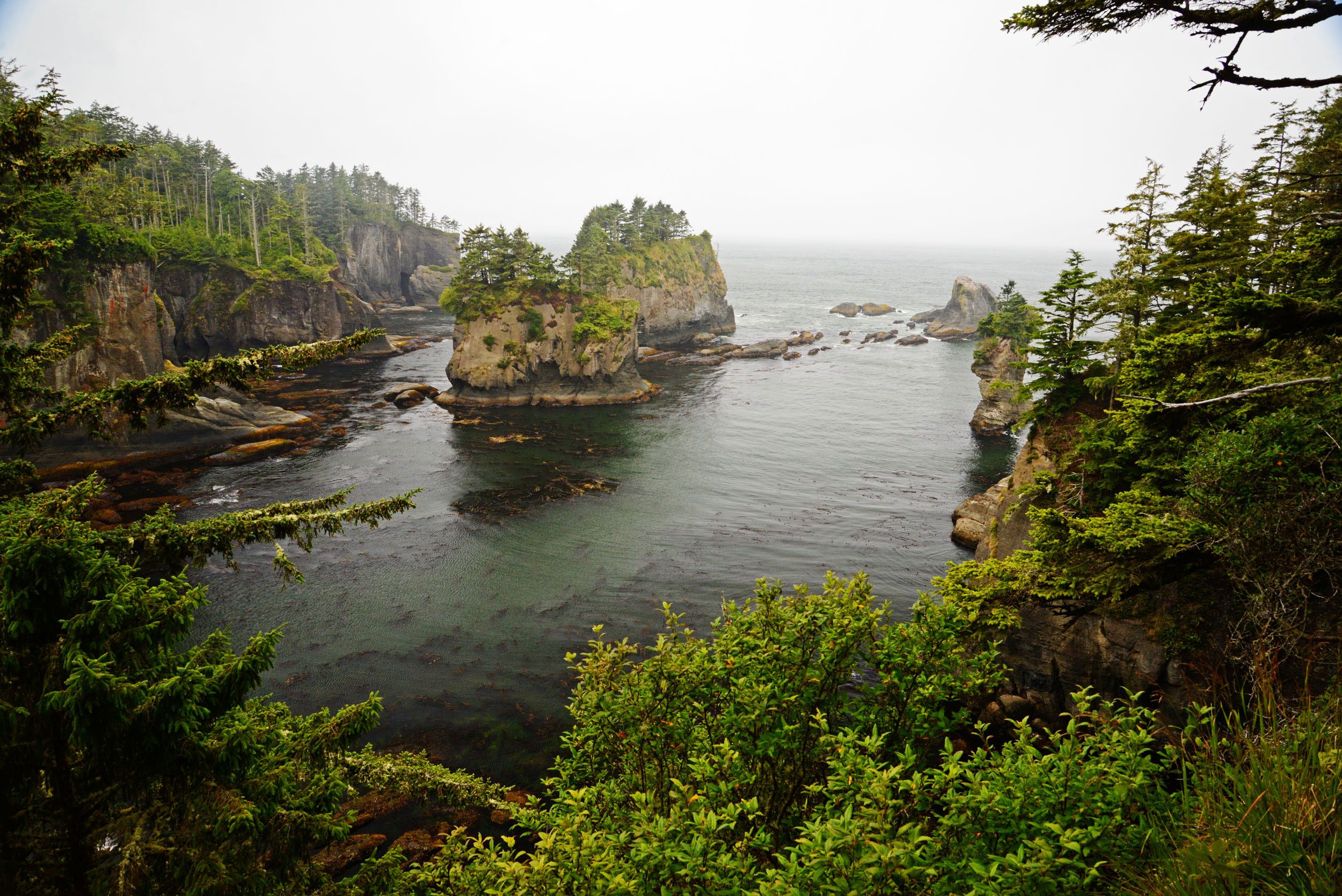
The outer coast of Washington state encompasses approximately 75 miles of shoreline between Cape Flattery and Grays Harbor. It is an ecologically rich and diverse area that includes some of the most scenic coastline in the world. Much of the coastal zone consists of wildlife sanctuaries.
Open to read more
Unlike most of Puget Sound, this region faces direct exposure to the constant waves and storms of the Pacific Ocean. Numerous forms of marine life thrive in this high energy environment. Kelp forests (Nereocystis and Macrocystis) provide important offshore habitat. Seabirds such as puffins, murres, marbled murrelets, gulls, and cormorants, and marine mammals such as harbor seals, sea otters and sea lions are at home here. Bald eagles are also common. Several of the rivers that empty into the Pacific Ocean are spawning areas for Chinook, Coho, and other anadramous fish. The coastal zone supports commercial fishing and some sport fishing areas, as well as many shellfish harvesting areas.
The Olympic Coast National Marine Sanctuary and Olympic National Park comprise much of the area, and indicate the importance of conservation for natural beauty and the diverse animal populations along the Outer Coast. Also included are 870 islands, rocks, and reefs which comprise the Flattery Rocks, Quillayute Needles, and Copalis National Wildlife Refuges managed by the U.S. Fish & Wildlife Service. In addition, the Makah Tribe, Quileute Tribe, Hoh Tribe, and Quinault Indian Nation each own land along the outer coast. Refer to Section 6 for detailed resource information.
Physical Features
Most of the outer coast is comprised of mixed sand and gravel beaches interrupted by rocky headlands. Small rocky islands lie offshore. Marsh areas and exposed tidal flats exist at the mouths of small creeks and rivers such as the Queets and Quillayute. In general, the northern part of the outer coast consists of rocky shores, inlets and coarse beaches; further south, it consists of sandy beaches and tidal flats. The outer coast includes the following shoreline habitats (NOAA 1984):
-
- Exposed rocky shores and seawalls
- Wave-cut platforms
- Mixed sand and gravel beaches
- Medium to coarse grained sand beaches
- Fine grained sand beaches
- Gravel beaches with exposed rip rap
- Sheltered rocky shores
- Exposed tidal flat
- Sheltered tidal flats
- Marshes
Hydrology
In the winter, inshore coastal currents typically flow northward. This winter current causes the Columbia River plume typically to flow northward, parallel along the Washington coast to the Strait of Juan de Fuca (however, some outflow may extend south of the Columbia River entrance). This movement has been described by Barnes, Duxbury and Morse (1972) and Hickey (1989). During the summer, predominant currents flow south. Therefore, at this time of year the Columbia River plume moves southwest of the river entrance and further offshore. Natural collection areas of oil and debris often occur in fronts forming along the seaward portion of the plume (Simecek-Beatty 1994).
Climate and Winds
Storm systems are most intense during the winter season (November – February). On the average, there is a permanent low pressure system hovering over a broad region off the eastern end of the Aleutian Island chain of Alaska that generates a series of storms in the North Pacific Ocean during a typical season. The prevailing winds of this period tend to be from the southwest and west at 10 to 20 mph (NOAA 1983).
Open to read more
In the spring (March – May), the Pacific Northwest begins to feel the effects of the high pressure system that usually exists year round off the southern California coast. This system gradually moves northward so that weather fronts become weaker as they try to penetrate through the high. An occasional powerful weather front passes through western Washington. Winds associated with this period tend to be west to northwest at 10 to 20 mph. One notable exception is near the entrance to the Strait of Juan de Fuca, where the winds tend to be southerly curving from the west at Cape Flattery.
In the summer season (June – August), the high pressure cell becomes well developed and stops the majority of storms from reaching the coast with full force. Winds of gale force seldom occur during these months. Sea breezes from the west are common in the Strait of Juan de Fuca. If the high moves into eastern Washington, hot easterly winds bring very warm temperatures. The prevailing northwest winds draw into the strait, increasing toward evening and at times blowing 25 knots before midnight. However, this occurs only when the winds are strong outside.
In the fall (September -November), the high pressure cell that dominated the area weakens and begins to move southward as more storms impact it from the west. If the high stays over the coastal area or slightly inland, warm summer weather can persist until late October when the dominant high is replaced by a series of dominant lows, and the rain returns. The prevailing winds for this period tend to be from the southwest. The winds in this area are a result of diverse topography including the Olympic and Cascade Mountains. The westerly winds from the Pacific appear to flow to the north and south around the Olympics, causing what is commonly known as the “Puget Sound Convergence” on the eastern side.
Maritime air from the Pacific has an influence on the climate throughout the year. In late fall and winter, air reaching the coast is moist and about 45° F. The wet season begins in late September to October.
From October through January, rain may be expected on about 26 days per month. The dry season begins in May with the driest period between mid-July and mid-August, with daytime temperatures in the upper sixties to low seventies. In summer and early fall, fog or low clouds form over the ocean and frequently move inland at night, but generally disappear by midday. In winter, under the influence of a surface high- pressure system, centered off the coast, fog, low clouds, and drizzle occur daily as long as this type of pressure pattern continues (NOAA 1994).
Tides and Currents
The oceanic current system off the Washington coast is comprised of the California current, Davidson current, and California undercurrent. The seasonal variation in the pattern of coastal circulation is the result of changes in direction of the dominant winds associated with large-scale atmospheric pressure cells over the Pacific Ocean (NOAA 1993). The relatively wide and straight continental shelf off the coast tends to separate the nearshore surface current from the larger-scale California current. Winter winds typically cause the southward flowing California current to remain offshore while nearshore, the Davidson current, flows toward the north. In the summer, northerly winds extend the southward flowing California current over both nearshore and offshore areas. Since spring and fall are transitional periods, changes in the local wind field results in unpredictable current reversals. Reversals can also occur within one to two days of change in the seasonal pattern (Simecek-Beatty 1994). Local nearshore currents within approximately 10 miles of shore are influenced by winds, ocean currents, tides, river runoff and coastal configuration, resulting in a high degree of local variation. In addition, there are many areas of coast upwelling during the summer and downwelling during the winter.
Open to read more
Five to twenty miles offshore, away from the immediate influences of the coast, the tidal current is quite different from the current found in inland tidal waters. Instead of setting in one direction for a period of 6 hours and in the opposite direction during the following period of 6 hours, the tidal current offshore changes its direction continually, so that in a period of 12 1/2 hours it will have set in all directions of the compass. This type of current is called a rotary current. Generally, they are elliptoid in shape and have a northeast to southwest axis, flooding to the northeast, and ebbing to the southwest.
Although the only nearshore tidal current information available is for the Quillayute River entrance, which has an average flood at 0.3 knots 115° and an average ebb at 1.3 knots 345°, strong tidal influences should be expected near inlets (NOAA 1995).
The mean tidal range (MHW-MLW) for the Washington coast is 6.6 to 6.3 feet and the diurnal range (MHHW-MLLW) is 8.7 to 8.14 feet (NOAA 1995).
Resources at Risk
This section provides a summary of natural, cultural, and economic resources at risk along the outer coast of Washington State, north of Grays Harbor. It provides general information on habitat, fish, and wildlife resources, and locations in the area where sensitive natural resource concerns exist. It offers a summary of cultural resources that include fundamental procedures for the discovery of cultural artifacts and human skeletal remains. A list of cultural and economic resources, as well as general information about flight restrictions, wildlife deterrence can be found near the end of this section.
Open to read more
This section is purposely broad in scope and should not be considered comprehensive. Some of the sensitive resources described in this chapter cannot be addressed in Section 4 (Response Strategies and Priorities) because it is not possible to conduct effective response activities in these locations. Additional information from private organizations or federal, state, tribal, and local government agencies should also be sought during spills.
This material is intended to provide general information about the area during the first phase of a spill response. During an actual incident, more information about resources at risk will be available from the Environmental Unit in the Planning Section.
Specific resource concerns related to areas that already have designated protection strategies (see Section 4) may be found in the “Resources Protected” column of the matrix describing individual strategies.
The information provided in this section may be useful in:
- Assisting the Environmental Unit (EU) in identifying resources at risk during a spill response and in developing additional response strategies beyond those found in Section 4.
- Providing resource at risk “context” to responders, clean-up workers, and others during the initial phase of a spill response in the GRP area.
- Briefing responders and incident command staff that may be unfamiliar with sensitive resource concerns in the GRP area.
- Providing background information for personnel involved in media presentations and public outreach during a spill incident.
Natural Resources at Risk – Summary
This area extends along the Washington outer coast from Copalis to Cape Flattery and contains a wide variety of aquatic, riparian, upland, and nearshore marine habitats. These habitats support many of Washington’s salmonid species as well as a complex diversity of other wildlife. In addition to those species directly at risk to oil spills, others (due to their life histories and/or behaviors) are unlikely to become directly oiled during a spill incident but may still be disturbed by operations such as cleanup, reconnaissance, or fire suppression activities. Some of the bird species are resident throughout the year, but many others seasonally migrate through the area.
Open to read more
Several of the species found in this area have been classified under the Federal Endangered Species Act or by the Washington State Fish and Wildlife commission.
In addition to the salmonid species listed below, it is also likely that other species of salmon associated with the Columbia River, the Straits of Juan de Fuca, and Puget Sound will transit the nearshore waters of this area.
Classification types are listed below:
- Federal Endangered (FE)
- Federal Threatened (FT)
- Federal Candidate (FC)
- State Endangered (SE)
- State Threatened (ST)
- State Sensitive (SS)
Federal and State listed species that may occur within this area include:
Birds:
- common loon [SS]
- marbled murrelet [FT/SE]
- northern spotted owl [FT/SE]
- sandhill crane [SE]
- short-tailed albatross [FE]
- steaked horned lark [FT/SE]
- tufted puffin [SE]
- western snowy plover [FT/SE]
- yellow billed cuckoo [FT/SE]
Mammals:
- blue whale [FE/SE]
- fin whale [FE/SE]
- fisher [FC/SE]
- gray whale (eastern north Pacific) [SS]
- gray whale (western North Pacific) [FE/SS]
- humpback whale (Central American population) [FE/SE]
- humpback whale (Mexican population) [FT/SE]
- killer whale (southern resident) [FE/SE]
- right whale (north Pacific) [FE/SE]
- sea otter [ST]
- sei whale [FE/SE]
- sperm whale [FE/SE]
Fish:
- bull trout [FT]
- eulachon [FT]
- green sturgeon [FT]
- Olympic mudminnow [SS]
- sockeye (Ozette Lk.) [FT]
Amphibians/Reptiles:
- green sea turtle [FT/ST]
- leatherback sea turtle [FE/SE]
- loggerhead sea turtle [FE/SE]
Critical habitats are the specific areas, occupied by an endangered or threatened species at the time it was listed, that contain the physical or biological features that are essential to the conservation of that species – and that may need special management or protection. Critical habitat may also include areas that were not occupied by the species at the time of listing but are essential to its conservation.
The following species have federally designated critical habitats within this area:
- bull trout
- eulachon
- green sturgeon
- leatherback sea turtle
- marbled murrelet
- sockeye (Ozette Lk.)
- western snowy plover
- humpback whale (Central American population)
- humpback whale (Mexican population)
General Resource Concerns
Habitats:
- Kelp beds occur along much of the coast north of Destruction Island. These habitats provide critical nursery areas for juvenile rockfish, salmonids and other fish and invertebrates. They also serve as prime feeding locations for many other wildlife species and create protected waters for resting sea otters and marine birds.
Open to read more
- Offshore waters (between the 20 m and 200 m isobaths) of the region seasonally support extremely large numbers of seabirds. These waters are important to marine fish and support both resident and migrating marine mammals. Regional and localized oceanographic conditions can greatly influence the temporal distribution and abundance of these resources.
- Coastal islands and rocks provide critical breeding and resting habitat for seabirds, birds of prey and marine mammals.
- Sand beaches, the primary habitat type along the south coast, provide habitat for razor clams, as well as for the vast numbers of shorebirds that stop over to feed and rest on the outer coast and its estuaries during the spring and fall migration.
- River and stream mouths provide salmonid spawning and rearing areas and are concentration areas for a variety of wildlife. The associated riparian scrub and woodlands play a crucial role in supporting a large diversity and abundance of songbird species as breeding, migrating, and overwintering habitat.
- Salt marshes provide critical habitat to a diverse array of fish and wildlife species. The few areas that exist along the open outer coast are especially important due to their rarity in this region.
- The subtidal habitats in this area consist primarily of:
- Soft sediments, such as clay, mud, sand, and gravel. These areas are broad flat and relatively level. Animals that tend to live on the surface of these habitats may include sea cucumbers, sea stars, crustaceans (such as crab and shrimp), and bottom fish such as skate, cod, and the flat fishes. These soft sediment habitats also support shellfish and other invertebrates including bivalves, worms, brittle stars, shrimplike crustaceans. The burrowing or foraging activities of these animals may penetrate up to one meter below the subsurface bottom.
- Rock reefs and shelves support a high level of species diversity. Many species of invertebrates, fish, birds, and mammals either live in this ecological zone or are dependent on it for feeding, rearing of young, or protection. These areas also serve as the foundation for kelp beds.
- Nutrient rich nearshore waters (from the shoreline out to the 20 m isobath) sustain a highly productive food web that includes fish, seabirds and marine mammals. These areas also serve as habitat for wide-ranging fish such as salmon, forage fish (herring, smelt, and sandlance), sharks, and a large number and variety of birds that utilize this habitat as foraging areas. These waters also support both resident and migrating marine mammals. Regional and localized oceanographic conditions can greatly influence the distribution and abundance of all these resources.
Fish, Shellfish, and Invertebrates:
- Salmonid spawning occurs in nearly all coastal rivers and streams from Copalis north to Makah Bay. Species present in this region are chinook, coho, pink, chum and sockeye salmon as well as steelhead, bull trout [FT] and cutthroat trout. Juvenile salmonids use shallow nearshore habitats extensively for feeding and rearing.
- The known distribution of forage fish (surf smelt and sandlance) spawning habitat on the outer coast is limited to small, isolated sites from the Raft River north to Kalaloch.
- Marine fish, representing a broad array of species, are widespread throughout this region. Juvenile fish using shallow nearshore habitats and those whose larval stages are present in upper layer of the water column are most vulnerable to oil spill impacts.
- Marine invertebrate populations of the intertidal and shallow subtidal habitats represent an abundant and highly diverse assemblage of species. Examples include various species of crab, sea urchin, snail, sea star, barnacle, sponge, octopus and bivalves. Dungeness crab and razor clam fisheries are important commercial species.
Wildlife:
- Seabirds, numbering in the tens of thousands, nest along the outer coast from Point Grenville north to Tatoosh Island off Cape Flattery- primarily on offshore rocks and islands. The most numerous species among these are auklets, storm petrels, murres, gulls, and cormorants. Marbled murrelet [FT] is unique in that they nest in mature tracts of coastal forests. Nesting birds and their young forage widely in both nearshore and offshore waters. Hundreds of thousands of other seabirds pass along Washington’s coast during migrations or are seasonal residents in offshore waters or along coastal beaches. Brown pelicans are abundant summer and fall residents, tending to form large flocks at river mouths, on coastal rocks and islands, and at the mouths of coastal estuaries and feeding in nearshore waters.
- Shorebird abundance on the outer coast is greatest from mid-August through mid-May, mostly along the sandy beaches and mud flats from Grays Harbor south to the Long Beach Peninsula. Black Oystercatchers nest on the rocky coastlines north of Point Grenville.
- Resident and migratory songbirds heavily utilize riparian habitats year-round and are susceptible to response activities in riparian vegetation.
- Bald eagles and peregrine falcons are common nesters along the coast north of Point Grenville. Migrant and winter resident peregrine falcons occur along all outer coast beaches.
- Six species of whales and dolphins regularly occur in this region’s nearshore zone. The entire U.S. population of gray whales migrates through Washington waters in the spring and fall, with many animals stopping to feed in shallow coastal waters during the northward migration in spring. Some individuals will typically leave the main migration and inhabit Washington’s nearshore waters throughout the summer. Humpback whales [FE] are coastal residents during the summer months, tending to concentrate in feeding areas offshore of Washington’s north coast. Killer whales (Orca) sighted off the outer coast are most commonly transient or offshore pods, but southern resident killer whale [FE] pods may also be seen, especially during the summer off the entrance to the Strait of Juan de Fuca. Harbor porpoise are common year-round and may be found from the surf zone out to several miles offshore. Both minke whales and Dall’s porpoise occasionally occur in nearshore waters. Numerous other species of whales or dolphins occur further offshore.
- Harbor seals are abundant in this region throughout the year, primarily from Cape Elizabeth northward, where they use islands and nearshore rocks for pupping and resting. Elephant seals are primarily pelagic but may occasionally haul out on Destruction Island. Northern fur seals are seasonally present in coastal waters but tend to stay well offshore and do not haul out on coastal rocks or islands. Steller sea lions are found year-round on the outer coast from Point Grenville northward, with peak numbers occurring during the fall and winter months. A small number of Steller’s pups are born annually on islands off the north coast. California sea lions are present in large numbers along the northern coastline from fall through early summer. There are no known California sea lion pupping areas in Washington.
- The great majority of Washington’s sea otter [SE] population occupies a range that extends roughly from Destruction Island to Cape Flattery, with only occasional individual animals found east of Cape Flattery. They are most commonly found within a mile or two of the mainland or offshore islands, especially in association with beds of giant kelp. The largest aggregation occurs in the waters surrounding Destruction Island. The northern outer coast also supports numerous river otters, which are very active in marine habitats close to shore, especially near the mouths of freshwater streams.
- Other mammals common to the region include semi-aquatic species such as beaver, muskrat, river otter, mink and raccoon. These small mammals are vulnerable to contact with spilled oil because of their habitat preferences. Larger mammals (deer, elk, etc.) are also present throughout
Specific Geographic Areas of Concern – Overview
Note: Includes sensitive sites that overlap with adjoining GRP regions – see area maps at end of chapter). For each area described below, there may be multiple management interests involved and these are noted where known.
Open to read more
Tatoosh Island to the Quillayute River (see Figure 1)
- Tatoosh Island: Very important seabird nesting area, home to the state’s largest nesting colony of common murres and large numbers of other seabird species. Kelp beds and complex rocky intertidal habitat. Steller sea lion and harbor seal haul out area. Small numbers of sea otters [SE] are present. (Olympic Coast National Marine Sanctuary (OCNMS), Tribal lands and resources)
- Cape Flattery: Kelp beds, complex rocky intertidal habitat and sea caves. Nesting area for seabirds, shorebirds, eagles and falcons. (OCNMS, Tribal lands and resources)
- Makah Bay: Kelp beds, rocky intertidal habitat and salmonid spawning rivers. Feeding area for sea otters [SE] and for both migrating and summer resident gray whales. (OCNMS, Tribal lands and resources)
- Anderson Point/Portage Head: Nesting area for eagles, falcons and seabirds. (OCNMS, Tribal lands and resources)
- Point of Arches area (Shi-Shi Beach to Father & Son Rocks): Kelp beds. Nesting area for eagles, falcons and seabirds. Sea otter [SE] and harbor seal feeding area. (National Park Service (NPS), OCNMS, USFWS)
- Cape Alava area (including Ozette Island, Bodelteh Islands & White Rock): Extensive rocky intertidal zone with numerous tidepools and offshore rocks, islands, and kelp beds. Diverse invertebrate populations. Feeding and rearing area for juvenile fish, including rockfish and salmonids. The Ozette River is used by Lake Ozette sockeye salmon [FT] and other salmonids and is a nesting area for harlequin ducks. Significant seabird nesting on the Bodelteh Islands and White Rock. Major feeding, resting and breeding area for sea otters [SE] and harbor seals, and one of state’s largest haulout areas for California sea lions and Steller sea lions [FT] during the fall. Nesting & foraging area for eagles and falcons. (NPS, OCNMS, US Fish and Wildlife Service (USFWS), Tribal lands and resources)
- Sand Point area (including adjacent rocks & islets): Extensive rocky intertidal habitat with numerous tidepools, rocks, islets and kelp beds. Diverse invertebrate populations. Feeding and rearing area for juvenile fish, including salmonids. Major feeding, resting and breeding area for sea otters [SE] and important harbor seal haulout and pupping area. (NPS, OCNMS, USFWS)
- Yellow Banks (~2.5 mi south of Sand Point): Extensive rocky intertidal and kelp habitat. Sea otter [SE] concentration area. (NPS, OCNMS)
- Carroll/Jagged Islands and vicinity: Major seabird nesting colonies and eagle and falcon nesting sites. Carroll Island is one of Washington State’s most important haulout areas for Steller sea lions. Major harbor seal haulout and pupping area and sea otter [SE] concentration area near Jagged Island. (OCNMS, USFWS)
- Cape Johnson and vicinity: Extensive rock reef, rocky intertidal, kelp, and tidepool habitat. Nesting and foraging area for eagles and falcons. Major concentration area for sea otters [SE]. (NPS, OCNMS)
- La Push area (including islands at river mouth): Surf smelt spawning on beaches from La Push north to Cape Johnson. The Quillayute River supports large numbers of various salmonid species. Seabird nesting area and year-round concentrations of marine birds in and around river mouth and adjacent islands. Nesting & foraging area for eagles and falcons. (NPS, OCNMS, USFWS, Tribal lands and resources).
Quillayute River to Raft River (see Figure 2)
- Quillayute Needles island complex: Kelp beds. Important seabird nesting area. (OCNMS, USFWS)
- Giants Graveyard: Extensive rocky intertidal habitat with kelp beds and numerous tidepools. Extremely rich invertebrate fauna. Sea otter [SE] resting and foraging area and major harbor seal haulout and pupping area. (NPS, OCNMS, USFWS)
- Hoh Head, Hoh River & vicinity: Surf smelt spawning beaches. Hoh River supports large numbers of a variety of salmonid species including bull trout [FT], as well as nesting harlequin ducks. Marine bird and sea otter [SE] concentrations at mouth of Hoh River and sea otter concentrations on the north side of Hoh Head. (NPS, OCNMS, Tribal lands and resources)
- Cedar Creek at Ruby Beach (including Abbey Island): Surf smelt spawning beaches. Cedar Creek provides spawning habitat for salmonids, including bull trout [FT]. (NPS, OCNMS)
- Destruction Island: Extensive kelp beds and rock reef habitat. Important area for Dungeness crab and rockfish. One of Washington’s largest seabird nesting colonies, supporting half of the state’s breeding population of rhinoceros auklets, together with many other species. Beaches and intertidal reefs of the island are important haulout and pupping habitat for harbor seals. Waters surrounding Destruction Island are home to nearly half of the state’s sea otter [SE] population. (OCNMS, USFWS)
- Kalaloch: Kalaloch Creek provides spawning habitat for salmonids, including bull trout [FT]. Razor clam beach. (NPS, OCNMS)
- Queets River mouth: Extensive salt marsh habitat just inside river mouth. Major river system used by a variety of salmonids, including bull trout [FT]. (NPS, OCNMS, Tribal lands and resources)
- Raft River & Tunnel Island: Extensive salt marsh habitat just inside river mouth. Raft River provides spawning habitat for salmonids, including bull trout [FT]. Seabird nesting area and year-round marine bird concentrations near mouth of river. (OCNMS, Tribal lands and resources)
Raft River to the mouth of Grays Harbor (see Figure 3)
- Split and Willoughby Rocks (and surrounding rocks): Seabird nesting colony. Important haulout area for Steller sea lions [FT]. (OCNMS, USFWS)
- Quinault River mouth and surrounding area: Major river system used by a variety of salmonids, including bull trout [FT]. Cape Elizabeth is a significant haulout area for harbor seals, as well as a nesting area for eagles and falcons. (OCNMS, Tribal lands and resources)
- Point Grenville area (including Grenville Arch and nearshore rocks & sea stacks): Important seabird nesting area. Harbor seal haulout area. (OCNMS, USFWS, Tribal lands and resources)
- Beach from Point Grenville south to mouth of Grays Harbor: Intertidal areas provide important razor clam habitat. Dungeness crab are abundant in both nearshore and offshore waters. Moclips River, Copalis River, and Joe Creek support a variety of salmonids including bull trout [FT]. Important shorebird feeding and resting area. Marine bird concentrations are common at stream and river mouths. Multiple state parks. (OCNMS waters extend south to Copalis Head. Tribal lands and resources from Point Grenville south to mouth of Moclips River).
Specific Geographic Areas of Concern – Maps and Descriptions

Figure 1: Tatoosh Island to the Quillayute River.

Figure 2: Quillayute River to Raft River.

Figure 3: Raft River to the mouth of Grays Harbor.
Cultural Resources at Risk – Summary
Numerous culturally sensitive areas exist along the shorelines of the region. A qualified archaeologist must approve any land-based spill response work that involves soil or sediment disturbance prior to initiation. Land-based spill response equipment, such as vacuum trucks, must stay on hardened surfaces until the area has been evaluated by an archaeologist.
Open to read more
There are also several different tribal and federal management interests that exist in the general area such as area Tribal Nations, the Olympic Coast National Marine Sanctuary, the U.S. Fish and Wildlife Service, the National Park Service, and the various Washington State trustees.
There is one fish hatchery in the area, the Bogachiel (Forks).
Economic Resources at Risk – Summary
Commercial, tribal, and recreational fisheries (targeting species such as salmon, crab, and razor clams) provide important local jobs and significantly contribute to local the economy.
General Information
Flight Restriction Zones: The Environmental Unit (Planning Section) may recommend flight restriction zones (FRZ) to minimize disturbance or injury to wildlife during an oil spill. Pilots/operators can decrease the risk of aircraft/bird collisions, prevent the accidental driving of wildlife into oiled areas, and minimize abandonment of nests by keeping a safe distance and altitude from these identified sensitive areas.
Open to read more
The Air Operations Branch (Operations Section) will manage all aircraft operations related to a response and will coordinate the establishment of any FRZs as appropriate. Environmental Unit staff will work with the Air Operations Branch Director to resolve any conflicts that arise between flight activities and sensitive resources.
Wildlife Deterrence: The Wildlife Deterrence Unit within the Wildlife Branch (Operations Section) manages wildlife deterrence operations. These are actions intended to minimize injuries to wildlife by keeping animals away from the oil and cleanup operations. Deterrence activities may include using acoustic or visual deterrent devices, boats, aircraft or other tools. The Wildlife Branch works with state and federal agencies, and the Environmental Unit (Planning Section), to develop deterrence plans as appropriate.
Oiled Wildlife: Capturing oiled wildlife may be hazardous to both personnel and the affected animals. Incident personnel should not try to approach or capture oiled wildlife but should report any observations of oiled wildlife to the Wildlife Branch (Operations Section).
National Marine Sanctuary and Wilderness Areas: The waters of this GRP region are almost entirely located within the boundaries of the Olympic Coast National Marine Sanctuary, with most of the marine shoreline being part of the Olympic National Park. Approximately 48 miles of the shoreline in the northern part of this area is also federally designated as a part of the Daniel J. Evans Wilderness Area.
Aquatic Invasive Species: The waters of this region are not known to contain aquatic invasive species (AIS), species of plants and animals that are not native to an area and that can be harmful to an area’s ecosystem. If found, however, preventative actions may be required to prevent the spread of these species as a result of spill response activities. The Environmental Unit can recommend operational techniques and strategies to assist with this if required.